History of East Palo Alto
About the City
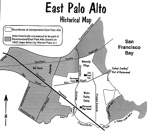
For most of its history, East Palo Alto was part of unincorporated San Mateo County. As such, it did not have an official boundary until it incorporated in 1983. However, the area historically regarded as East Palo Alto was much larger than the city's current 2.5 square miles. (See map). Large tracts were annexed by Menlo Park and Palo Alto from the late 1940s to the early 1960s.
The People
The original inhabitants were Ohlone / Costanoan Native Americans. Spanish ranchers took over, followed by Caucasian speculators and settlers. For a time Chinese laborers were prevalent. Asian and Italian flower growers preceded the flood of middle-class Caucasians drawn to post-war housing developments. East Palo Alto later became the largest African American community on the peninsula. Today the city possesses a multi-ethnic population which includes a large number of Hispanics and Pacific Islanders.
Trade
Trade has alternately focused on ranching, transportation and shipping, brick manufacturing, farming, servicing travelers of Bayshore Highway and Dumbarton Bridge, and flower growing. At present there is a mix of small industrial, agricultural and commercial businesses.
Growth
These changes, and the population shifts that accompanied them, may be partially responsible for the notion that East Palo Alto lacks the kind of strong community identity possessed by its neighbors. Since it was founded around 1849, the town has experienced erratic growth and frequent conflict.
City Characteristics
But some things have remained constant, namely the characteristics that have always attracted people to the area: the price of land and housing; a beautiful, rural-like setting; its centralized location; proximity to transportation and San Francisco Bay; and some of the most enviable weather in the nation.